Saturday, 29 January 2022

Checking Towpath Access at Brighouse

Coming info Brighouse from Sowerby Bridge at the west, the towpath is on the north of canal, but coming out of Brighouse towards Bradley, the towpath is on the south side to Cooper Bridge (coming off early after Bradley Viaduct 21m via Lower Quarry Road because of collapsed towpath).

But within Brighouse, on the east of Brighouse Basin the towpath is inaccessible on both sides so some route must be found from Brighouse Basin to Anchor Pit Bridge 9.

The urban route from Brighouse Basin to Anchor Pit Bridge 9

The urban route takes Armytage Road from Brighouse Basin, then Huntingdon Road across Blakeborough's Bridge and the canal, and then River Street to Anchor Pit Bridge 9, requiring a diversion from the waterside for about a mile.

Today we looked to see if more towpaths might be used (and for a more pleasant walk) as well as where the north side path became impassible.

On the north side we found a short stretch that was very accessible but did not reach either Brighouse Bottom or the motorway. It might be used as an early exit from Armytage Road (at Priory Road or before) to Blakeborough's Bridge


These images showing the inaccessible section in red are show below.

The impassible north east (left) and the passable south (right) from which the other pictures were taken


View of the impassible north taken from the south


Futher view of the impassible north taken from the south


Images are shown below of the first route to the towpath from Armytage Road and Brighouse Basin, before the well marked Priory Road route.

A view from Armytage Road of the Bathroom Showroom, to the right of which entry can be gained to the north-side towpath through a small gate
A close up of the small pedestrian gate offering access to the northside towpath

It becomes clear then that most of Armytage Road route can be replaced by a canal side walk on a well kept towpath, and Blakeborough's bridge can be used to cross to the south side.

The question remains whether there is any usable towpath on the south side before the east end of River Street. The Canal & River Trust map clearly indicates one, but is it usable?
The Canal & River Trust map indicates a footpath from Blakeborough Bridge to Anchor Pit Bridge 9

To check this route we parked at the end of River Street and walked back to the bridge.
River Street back to Blakeborough Bridge

Access from the bridge is via a long drop (on the right of the image below) to the towpath under the bridge. Climbing back up will be impossible for all except perhaps tall men between 15 and 25 years old.

Jump from the footpath on the right down about 6 feet to the towpath on the left

The route was definitely "passable" but perhaps not very easily. Even in winter, the parts nearer the bridge had a definite jungle aspect, with plenty of brambles, and I'm not convinced it will be a good route in the summer.

The urban route along river street will be much preferable and is well shaded in the summer.

The south side from the bridge. It gets worse before it gets better.


The recommended route is shown in blue below with an optional section in red for adventurous people.


Saturday, 22 January 2022

Scouting an Improved Mirfield Diversion

Heading into Mirfield from Bradly, the canal towpath must be abandoned near the new housing estate, as the towpath is impassable. Previously we had followed the southern blue path all the way, which in the hot weather involves a long hot urban0desert walk along the side of the train lines, with no breeze.

Last week, we discovered a canal-based route following the purple path.

New northerly (purple) towpath based route

It is not shorter, but I expect more pleasant in the heat. It joins the blue route close to Lidl -- useful for toilets, and also for supplies. It is a great place to get some restorative frozen snacks, water, or other supplies -- the build is air-conditioned, so just a stroll around temptations aisles does wonders to recharge failing stamina. 

Pit-stop LIDL

There is still quite an urban diversion that is not to be avoided. I believe there once was a better river route as shown, over a now absent bridge, whose stanchion remains to hint what once was there.


 The visible route on the east side doesn't continue north-west for long, and leads to Huddersfield Road which must be followed until Wood Lane bridge when the towpath on the south can be re-joined (not a good route).

Scouting Between Brighouse Basin and Fearnley Mill Drive (Bradley)

On our first walk from Sowerby Bridge we tool the the west side canal walk from Brighouse to Bradley but the towpath got progressively more impassible, partly due to the summer foliage, but ultimately due to the towpath area in blue being collapsed in multiple places. Eventually, we had to climb up the slope of a toppled fence into the Fearnley Mill Drive Industrial Estate.

The section marked has multiple towpath collapses

On subsequent walks in the other direction, we did not fancy climbing back down the same toppled fence sloping towards a very narrow (and possibly now missing) towpath, so we took the urban route from Fearnley Mill Drive taking the A62 north to the A644 north west to the M62 (over or under) and heading to Brighouse Marina via Armytage Road. It was very noisy, and the footpath on the A644 was so narrow in parts that crossing it twice was required. All very unsatisfactory.

Other routes could be explored, but halfway through a 20+ mile walk is not the setting to explore, so we took some time out to examine alternate exit points from the west side path to Fearnley Mill Drive.

The maps indicated some possible farm tracks from the canal to Lower Quarry Road so we set out to investigate those.

The Path from Fearnley Mill Drive

We went into the industrial estate to see whether there was formal access to the towpath, that we had missed before. At the area marked in red on the map there was easy over the fence access to good stable towpath if it were possible to even get that far south which was doubtful.

The towpath is collapsed at multiple points between the top of the map and the red mark

I spoke with someone working in the industrial estate who confirmed that the towpath was collapsed at multiple points and had been so for years, and that the only safe way to get access to Brighouse along the towpath was (as we suspected) via Lower Quarry Lane and some farm tracks.

The Path from Brighouse


We investigated all of the paths marked blue. Coming south it seems best to leave the towpath immediately after passing under the Bradley Viaduct as shown below.

Bridge 21 Bradley Viaduct. Take the footpath right to Lower Quarry Road immediately after passing under this bridge

We walked the whole area to explore all the possibilities. While there is also a path across on the other side, it does not look to continue very far towards Brighouse.

View towards the canal and Bradley Viaduct from the footpath. Note the footpath on the other side

For those who prefer to stay by the water for as long as possible, it is possible to cross a little stream (which will take some care) and continue along the towpath a little further, and then cut through a field along a well-worn track and under a railway bridge, also leading to Lower Quarry Road.

The well worn track coming from the left to towards the bridge and Lower Quarry Road

The bridge to Lower Quarry Road

Whether you leave to towpath immediately after the passing under the viaduct, you can cross the railway at a level cross or continue around the curve of the field track and cross under the bridge.
A view of the level crossing looking forward to the canal

We did also continue as far down the towpath as possible until we reached a point where we didn't care to continue any further. We had already had to step over some small collapse of the path, and this corner looked a good place to drown. Note on the right - the fencing to the industrial estate, and the slope down towards a narrow towpath. 

This point was considered to be the end of the passable towpath,

Conclusion

Our conclusion was that (coming south) it was best to leave the canal immediately after the Bradley Viaduct but follow the path around to pass under the railway (rather than at the level crossing) and avoid the stream and reduce time spent on the Lower Quarry Road.

We met a local dog walker who confirmed how to pronounce Slaithwaite (which I've sadly since forgotten) and also confirmed that the path to Brighouse is passable all the way from the Bradley Viaduct, except that canal must abandoned coming into Brighouse (which we knew from our very first walk)

Leaving the canal at Baleborough's Bridge (Huntingdon Road) to take Armytage Road to Brighouse Basin


Saturday, 8 January 2022

Scouting between Dewsbury and Shepley Marina

In July 2020 the towpath from Shepley Marina (Shepley Lock Br 16) to Dewsbury (to the Spen Valley Greenway, Long Cut End Br 19) was impassable.


Specifically from Greenwood Lock Fb 18 to Ravensthorpe Br 27, was so crammed with Hymalayan Balsam that progress was very slow and involved the firemans "smoky room" sideways walk to crush the foliage blocking the path with each step. 

It was very difficult to know where the towpath was, and on one place it had a hole which I nearly fell down.
The hole I nearly fell down when the path was overgrown by Himalayan balsam.

In summer 2021 when travelling the other direction towards Shepley Marina we met a Duke of Edinburgh expedition group coming the other way and learned that they did not take the footpath from the marina. but came via the main Huddersfield road (A644), which confirmed our previous conclusion that the towpath was impassable.

Today (Jan 2022) the path was very clear, with only a little hymalyan balsam stalks visible at all, so it hasn't very recently been cleared.

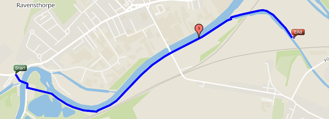
We verified that there is a route following the north side from Shepley Lock Br 16, crossing to the south side at Ravensthorpe Br 27, back to the north side at Long Cut End Br 19 and continuing along the Spend Valley Greenway.


Although the Canal and River Trust map doesn't show a footpath on the south side of the river between 19 Greenwood (by The Ship Inn) and Sheply Br 27, google satellite maps have evidence of one, as does gmaps pedometer, so this could be an alternate route.


We did not verify that route today, except the start at Ravensthorpe Br 27. The view from across the river indicated that it was more shaded and likely to be clearer.

It was getting too dark to verify the western end of the south side of the river, so we leave that to another day.


Facebook page: Towpath Trails

 See the new facebook page: towpathtrails which may be a better way to interact if you want to do more than just follow the blog.

Calder and Hebble Group Walk

We're making initial plans and doing route scouting for our 2022 Calder and Hebble canal walk. You can join us for all or part of the route.

Route

Route: Full length Calder & Hebble Navigation Canal (Sowerby Bridge to Wakefield)
Length: About 24 miles
Duration: 13 hours (10 hours moving time)

You can come and go as you please, but the full route will be from Sowerby Bridge train station, heading through Elland, Brighouse, Mirfield, Dewsbury, Horbury, Wakefield, stopping off at the famours Brookfoot Beach, and Horbury Beach (near Ossett Brewery) to finish at Fall Ings which is a 15 minute walk to Kirkgate Station or a 15 minute walk to Sandal & Agbrigg Station and so is good for services via Leeds or Dewsbury or Huddersfield.

Full details: 2022 Calder & Hebble

Checking Towpath Access at Brighouse

Coming info Brighouse from Sowerby Bridge at the west, the towpath is on the north of canal, but coming out of Brighouse towards Bradley, th...